When I started writing this blog, I never thought that
U.S. Route 50, comprised of Columbia
Parkway and Wooster Pike in Fairfax, would be a worthy topic for an article.
After all, it has never really been the pride and joy of our community in the
way that, say, Fairfax School was. Through most of our history it has been sort
of unflattering, known for the proliferation of gas stations, auto repair
places, and fast-food joints. My dad always called it “the main drag,” but I
got the sense he was using it in a derogatory manner, like it wasn’t really
much of a main street. However, when deciding on the topic for my next article,
I noticed that I had accumulated a good deal of information about Columbia
Parkway and Wooster Pike.
Our story doesn’t have a definite beginning. Most
accounts say that what is now Wooster Pike began as path or trail through the
wilderness which developed into a wagon road that ran between Cincinnati and Chillicothe.
Stage coaches, covered wagons, and livestock used the road. The Joseph Ferris
family built their home, now located at the intersection of Dragon Way and
Wooster, near the road. Farther east, the first school in the area and the
Ferris family cemetery were built on the road. Joseph’s brother Eliphalet
Ferris built his home a little north of the road. The house that is now 50 West
Brewpub was built along the road in 1827.
Joseph Ferris House, Dragon Way & Wooster Pike, Fairfax, Ohio
In the early 1800s there were few roads connecting the major
towns in the State of Ohio. The young state didn’t have the financial resources
to build roads without raising taxes, so the state government began granting
charters to private turnpike companies that would build and maintain the roads.
The turnpike companies sold stocks to investors and made money by charging
tolls.
In February 1828, the Cincinnati, Columbus and Wooster
Turnpike Company was chartered with capital of $200,000. The turnpike
ultimately ran from Linwood (where Eastern Avenue now ends) to Goshen. The
final portion of the turnpike in Goshen was completed in 1841. The turnpike
never made it as far as Wooster, Ohio. Using today’s roads as reference, going
east, the turnpike roughly followed Wooster Pike from Linwood into Fairfax,
Mariemont, Terrace Park, and Milford. At Five Points in Milford, the Wooster
Turnpike veered left toward Goshen.
Turnpikes were typically macadamized, a style of pavement
using crushed gravel. After several decades of use and lax street repairs, by the
turn of the 20th century most turnpikes were in poor condition. Local
governments began to condemn (“to declare convertible to public use under the
right of eminent domain,” per Merriam Webster) turnpikes. In October 1910,
Hamilton County Commissioners adopted resolutions to condemn the Wooster
Turnpike from Red Bank (now western Fairfax) to Milford. In June 1911, Hamilton
County purchased its portion of the Cincinnati, Columbus and Wooster Turnpike
for a little over $25,000.
So, Hamilton County became responsible for the
Cincinnati, Columbus and Wooster Turnpike, or Wooster Turnpike, or Wooster
Pike, or Eastern Avenue; these names were used interchangeably for the road in
the early part of the 20th century. The Fairfax subdivision was
platted in 1910 and the Madison Heights and Dublin Springs subdivisions in
1913. Apparently, the road was not in great condition, since some early Fairfax
residents recalled cows grazing on Wooster Pike. At some point, the street
paving was upgraded with some degree of maintenance. Through the years, the
road was widened and straightened to accommodate modern traffic.
These days, there are only three structures along
Wooster Pike in Fairfax that were built as houses. However, Wooster Pike once
had a number of residences. This Sanborn Fire Insurance Map from the early
1950s shows the homes on the Pike between Southern and Lonsdale. Yellow
markings designate dwellings, green for stores, blue for restaurants, and
purple for gas stations and auto repair.
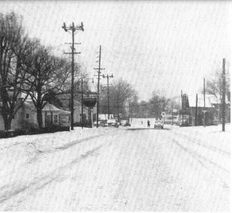
Wooster Pike in 1955, looking west from Watterson Road. The sign
slightly left of center marks the Kream Kottage restaurant.
From A History of the Village of Fairfax by Elizabeth Steele and Patricia Kuderer
With growing numbers of workers travelling daily between
Cincinnati and the eastern suburbs, traffic became problematic between downtown
and Fairfax, prompting a Cincinnati Enquirer columnist to call Wooster
Pike/Eastern Avenue “a commuter’s nightmare.” The stretch of Wooster Pike between Linwood and
Red Bank Road was inadequate for the volume and type of traffic it handled each
day and was plagued by potholes.
Columbia Parkway had been built as a Works Progress
Administration project and opened in the late 1930s. The Parkway originally ran between Downtown Cincinnati and Beechmont Avenue. In March 1955, the Hamilton County
Commission announced a multi-million dollar highway plan that included
extending Columbia Parkway from Beechmont to Wooster Pike near Southern Avenue in
Fairfax. 75 percent of the cost would be paid by the City of Cincinnati and the
other 25 percent by Hamilton County. The extension would allow traffic to
bypass the congested Wooster Pike – Red Bank Road intersection.
I learn so much I never knew from researching this blog.
Not that this is earth-shattering, but the section of Wooster Pike between
Meadowlark and Southern didn’t always run where it is today. For my entire
life, Columbia Parkway has run directly into Wooster Pike at Meadowlark Lane. “Old”
Wooster Pike curves north to join Wooster Pike and intersect Columbia Parkway
at Meadowlark. However, before the Columbia Parkway extension, it was a
straight shot from Old Wooster to Wooster Pike near
Southern.
1950 Map of Fairfax, from loc.gov.
Perhaps it’s my imagination, but I can visualize where
the street must have been back in the day. I took this photo slightly west of
the intersection of Southern and Wooster. It seems that this would be the point
where the section of road we often call Old Wooster would connect to this
section of Wooster Pike:

Below is an aerial view of the Strietmann plant (now
Kellogg’s) from 1956. Wooster Pike is visible on the left side of the
photograph. Part of the wooded area between Strietmann’s and Wooster Pike would
later become Dragon Way.
From The Messenger, July 28, 1956
In October 1958, Foley Construction was awarded the
contract for building the Columbia Parkway extension. On October 28, Ohio Governor C. William
O’Neill joined Fairfax Mayor John Dinkel and Mariemont Mayor E. Boyd Jordan at
the corner of Meadowlark Lane and Wooster Pike to turn the first spade of dirt
for the project.
By December 1960, the northern side of the Columbia
Parkway extension from Red Bank Road to Wooster Pike at Meadowlark Lane was
open to traffic. Construction continued. Did it continue without a hitch? Of
course not.
In January 1962, the extension was complete with the
exception of a 200-foot section near Southern Avenue. Seeding, sodding, and
shoulder work also needed to be completed and couldn’t be done until spring.
Foley Construction agreed to open the road, but only if Cincinnati and Fairfax
would accept liability for structural damage and worker injuries occurring
before the contract was completed. Both
Cincinnati and Hamilton County had approved the road opening. Cincinnati would
pay 75 percent of the insurance premium.
Construction of the Columbia Parkway extension west of Meadowlark Lane.
The Frisch's Mainliner parking lot and sign are visible in the upper left quadrant of the photo.
From the January 18, 1962 Cincinnati Enquirer
Fairfax officials did not agree to open the roadway. They
feared that the traffic congestion resulting from the early opening
would create a hazard. Only the two lanes on the northern side would be ready and until the project was complete, two lanes of traffic in
each direction would be merging into one lane each way. The village didn’t have
the money to pay its share of the insurance premium either.
This diagram from the February 8, 1962 Cincinnati Post shows the status of the
construction between Meadowlark and Southern when discussion of early opening
of the Columbia Parkway extension began.
Within a few weeks, though, the City of Cincinnati,
Hamilton County, and Fairfax had reached an agreement to open the extension
early with Cincinnati and Hamilton County paying the insurance premium. On
February 22, traffic lights and road signs were installed and final cleanup was
done in preparation for opening the following day. Fairfax Police Chief Jim
Finan was expecting the worst and directed traffic himself. The project was
completed within a few months.
Most of the houses on Wooster Pike were disappearing and replaced
with an ever-changing variety of businesses. Now we had the Main Drag I grew up
with. My siblings, friends, and I had a lot of fun around the Pike as kids. In
a family with both parents employed full-time, we made a lot of trips to
Frisch’s Mainliner for carryout. The car wash was a goldmine for soda bottles,
which we would cash in at the Pony Keg or Convenient Food Mart. We pumped our
arms at passing truck drivers so they would sound their horns. My friends and I
went to the Provident Bank grand opening and loaded up on the free food. My
first and last shoplifting attempt was at King Kwik at the age of three or four,
when I snatched some chocolate-covered cherries, only to have my mom march me
back into the store to pay for them and apologize. So many memories – Clara Sallee
ringing up our purchases at Atwood’s Pharmacy, the fixings bar at Burger Chef,
the crossing guard, Mr. Lucking, helping us cross Wooster at Germania – it was
great.

Wooster Pike between Lonsdale and Watterson
From The Chieftain, Mariemont High School, 1984
Despite all of these nice childhood memories, Wooster
Pike wasn’t exactly paradise. It was handy to have gas, auto repair, fast food,
and convenience stores close at hand, but it wasn’t pretty. In 1976, the
village initiated an improvement program, but, to my eye, the improvements were
minor at best. There were utility wires running from one side of the road to
the other and an unattractive tall chain link fence between Southern Avenue and
Meadlowlark Lane. Not all of the business properties were well-maintained and
neat. The road was also dangerous for pedestrians with sand and gravel-covered
sidewalks directly bordering the busy roadway.
In the early 2000s, village officials announced another Wooster
Pike revitalization project. A committee of residents and businesses worked on the project and a consulting firm was engaged. Over time, the project evolved. Obviously, most of the changes on the Draft Comprehensive Redevelopment Plan below never occurred.
March 2003 Fairfax-Wooster Corridor Draft Redevelopment Plan
The planned improvements were intended to make the road safer for
vehicle traffic and pedestrians and to attract businesses. One component of the
project was creation of a western gateway with trees, shrubbery, and brick walls announcing “Welcome to Fairfax.” The tentative plans also included eliminating some
driveways on the Pike, requiring business signs to be more uniform, moving all
utility poles to one side of the road, making some intersecting residential
streets into cul-de-sacs, and extending Watterson south of Wooster and creating
a town square. Mayor Ted Shannon said the project “should give us an identity
we don’t have now. A lot of people don’t even know they’re driving through
Fairfax.” The project was expected to take five to ten years and would be
completed as funding became available.
It took a few years for the Wooster Revitalization
Project to get rolling. By 2010, state and federal funding had been lined up. At
that point, plans included converting the road from four to three lanes (two
through lanes and a center turn lane), a buffer between the sidewalks and
street, new upgraded traffic lights, irrigation improvements, and, of course, making
some residential streets dead ends or cul-de-sacs. In addition, aesthetic
improvements were planned, to include benches, trash receptacles, planters, and
a 35-foot bell tower in front of Frisch’s. The aesthetic improvements would be
funded by resident and business donations and would be purchased and installed
only to the extent that donations were received.
This project might have been the
most controversial in the village’s history. Germania, Lonsdale, Simpson,
Carlton, and Camden were all being converted from streets that intersected with
Wooster Pike to cul-de-sacs or dead ends with the intention of improving
traffic flow on Wooster. Some residents on Watterson complained that the
changes had increased traffic on their street and called for construction
to be halted. Others felt blind-sided by the creation of the
cul-de-sacs. Village officials said they made every effort to keep residents
informed and had held at least a half dozen public meetings about the project
since 2001.

Mayor Ted Shannon posing with one of the new decorative street lights.
From the Eastern Hills Journal, February 10, 2010
Ultimately, the cul-de-sacs and dead ends were constructed
as planned. Wooster was reduced from four to three lanes, which caused long rush
hour backups for months afterwards as commuters adjusted to the new traffic pattern. The
speed limit was reduced from 35 to 25 miles per hour. Bus pull-offs were
installed near Meadowlark, Watterson, and Camden, and a bus shelter was
constructed at Meadowlark. New sidewalks were installed with pavers creating a
buffer between the sidewalks and road. The western gateway was landscaped and a
large stone sign proudly proclaiming “Village of Fairfax” was installed. Decorative
street lighting was added. Pedestrian crossing lights were installed. Unused
utility poles were removed and utility poles were all consolidated on the south
side of the road. The aesthetic elements (benches, trash receptacles, planters)
didn’t receive the amount of funding village officials hoped for, but
some of these amenities can be found on Wooster Pike and throughout the
village. The Watterson extension, town square, and bell tower didn’t happen.
I won’t comment on whether this project improved traffic
flow or pedestrian safety, but
I will say that I think it achieved the goal of making Wooster Pike and Fairfax
more attractive. It achieved the goal of informing people entering the village
from the west that they are in Fairfax. It made drivers slow down to see what’s
here. Can you tell when you have left Mariemont and entered Fairfax without a
big “Village of Fairfax” sign at the eastern gateway? Yes, of course. Our Main
Drag isn’t peaceful and tree-lined, but here you can fill your tank, buy a bike, grab a Big
Boy and fries, and pick up the best doughnuts in the Cincinnati area. That is
our identity. That’s Fairfax to me!
What does the future hold for the Main Drag? As I write
this, a new residential development is being constructed near the southeastern
section of the Pike and drivers have voiced concern over increased traffic. Will
the current configuration of Wooster Pike stand the test of time? We will see.
Wooster Pike facing east from Meadowlark Lane, 2023